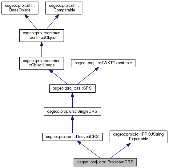
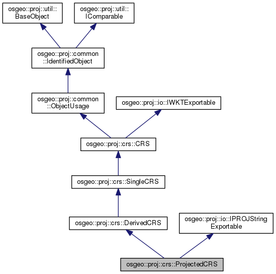
|
PROJ C++ API
|
|
PROJ C++ API
|
A derived coordinate reference system which has a geodetic (usually geographic) coordinate reference system as its base CRS, thereby inheriting a geodetic reference frame, and is converted using a map projection. More...
#include <crs.hpp>


Public Member Functions | |
| const GeodeticCRSNNPtr & | baseCRS () PROJ_CONST_DECL |
| Return the base CRS (a GeodeticCRS, which is generally a GeographicCRS) of the ProjectedCRS. More... | |
| const cs::CartesianCSNNPtr & | coordinateSystem () PROJ_CONST_DECL |
| Return the cs::CartesianCS associated with the CRS. More... | |
| bool | isEquivalentTo (const util::IComparable *other, util::IComparable::Criterion criterion=util::IComparable::Criterion::STRICT) const override |
| Returns whether an object is equivalent to another one. More... | |
| CRSNNPtr | shallowClone () const override |
| Return a shallow clone of this object. | |
 Public Member Functions inherited from osgeo::proj::crs::DerivedCRS Public Member Functions inherited from osgeo::proj::crs::DerivedCRS | |
| const SingleCRSNNPtr & | baseCRS () PROJ_CONST_DECL |
| Return the base CRS of a DerivedCRS. More... | |
| const operation::ConversionNNPtr | derivingConversion () const |
| Return the deriving conversion from the base CRS to this CRS. More... | |
 Public Member Functions inherited from osgeo::proj::crs::SingleCRS Public Member Functions inherited from osgeo::proj::crs::SingleCRS | |
| const datum::DatumPtr & | datum () PROJ_CONST_DECL |
| Return the datum::Datum associated with the CRS. More... | |
| const datum::DatumEnsemblePtr & | datumEnsemble () PROJ_CONST_DECL |
| Return the datum::DatumEnsemble associated with the CRS. More... | |
| const cs::CoordinateSystemNNPtr & | coordinateSystem () PROJ_CONST_DECL |
| Return the cs::CoordinateSystem associated with the CRS. More... | |
 Public Member Functions inherited from osgeo::proj::crs::CRS Public Member Functions inherited from osgeo::proj::crs::CRS | |
| GeodeticCRSPtr | extractGeodeticCRS () const |
| Return the GeodeticCRS of the CRS. More... | |
| GeographicCRSPtr | extractGeographicCRS () const |
| Return the GeographicCRS of the CRS. More... | |
| VerticalCRSPtr | extractVerticalCRS () const |
| Return the VerticalCRS of the CRS. More... | |
| CRSNNPtr | createBoundCRSToWGS84IfPossible (io::DatabaseContextPtr dbContext) const |
| Returns potentially a BoundCRS, with a transformation to EPSG:4326, wrapping this CRS. More... | |
| CRSNNPtr | stripVerticalComponent () const |
| Returns a CRS whose coordinate system does not contain a vertical component. More... | |
| const BoundCRSPtr & | canonicalBoundCRS () PROJ_CONST_DECL |
| Return the BoundCRS potentially attached to this CRS. More... | |
 Public Member Functions inherited from osgeo::proj::common::ObjectUsage Public Member Functions inherited from osgeo::proj::common::ObjectUsage | |
| const std::vector< ObjectDomainNNPtr > & | domains () PROJ_CONST_DECL |
| Return the domains of the object. | |
 Public Member Functions inherited from osgeo::proj::common::IdentifiedObject Public Member Functions inherited from osgeo::proj::common::IdentifiedObject | |
| const metadata::IdentifierNNPtr & | name () PROJ_CONST_DECL |
| Return the name of the object. More... | |
| const std::string & | nameStr () PROJ_CONST_DECL |
| Return the name of the object. More... | |
| const std::vector< metadata::IdentifierNNPtr > & | identifiers () PROJ_CONST_DECL |
| Return the identifier(s) of the object. More... | |
| const std::vector< util::GenericNameNNPtr > & | aliases () PROJ_CONST_DECL |
| Return the alias(es) of the object. | |
| const std::string & | remarks () PROJ_CONST_DECL |
| Return the remarks. | |
| bool | isDeprecated () PROJ_CONST_DECL |
| Return whether the object is deprecated. More... | |
| std::string | alias () PROJ_CONST_DECL |
| Return the (first) alias of the object as a string. More... | |
| int | getEPSGCode () PROJ_CONST_DECL |
| Return the EPSG code. More... | |
| bool | isEPSG (int code) PROJ_CONST_DECL |
| Return whether the object has a identifiers() in the EPSG code space. | |
 Public Member Functions inherited from osgeo::proj::io::IWKTExportable Public Member Functions inherited from osgeo::proj::io::IWKTExportable | |
| std::string | exportToWKT (WKTFormatter *formatter) const |
 Public Member Functions inherited from osgeo::proj::io::IPROJStringExportable Public Member Functions inherited from osgeo::proj::io::IPROJStringExportable | |
| std::string | exportToPROJString (PROJStringFormatter *formatter) const |
| Builds a PROJ string representation. More... | |
Static Public Member Functions | |
| static ProjectedCRSNNPtr | create (const util::PropertyMap &properties, const GeodeticCRSNNPtr &baseCRSIn, const operation::ConversionNNPtr &derivingConversionIn, const cs::CartesianCSNNPtr &csIn) |
| Instanciate a ProjectedCRS from a base CRS, a deriving operation::Conversion and a coordinate system. More... | |
 Static Public Member Functions inherited from osgeo::proj::common::IdentifiedObject Static Public Member Functions inherited from osgeo::proj::common::IdentifiedObject | |
| static IdentifiedObjectNNPtr | create (const util::PropertyMap &properties) |
| Instanciate a new IdentifiedObject. More... | |
Additional Inherited Members | |
 Public Types inherited from osgeo::proj::util::IComparable Public Types inherited from osgeo::proj::util::IComparable | |
| enum | Criterion { Criterion::STRICT, Criterion::EQUIVALENT } |
| Comparison criterion. More... | |
 Static Public Attributes inherited from osgeo::proj::common::ObjectUsage Static Public Attributes inherited from osgeo::proj::common::ObjectUsage | |
| static const std::string | SCOPE_KEY |
| Key to set the scope of a common::ObjectUsage. More... | |
| static const std::string | DOMAIN_OF_VALIDITY_KEY |
| Key to set the domain of validity of a common::ObjectUsage. More... | |
| static const std::string | OBJECT_DOMAIN_KEY |
| Key to set the object domain(s) of a common::ObjectUsage. More... | |
 Static Public Attributes inherited from osgeo::proj::common::IdentifiedObject Static Public Attributes inherited from osgeo::proj::common::IdentifiedObject | |
| static const std::string | NAME_KEY |
| Key to set the name of a common::IdentifiedObject. More... | |
| static const std::string | IDENTIFIERS_KEY |
| Key to set the identifier(s) of a common::IdentifiedObject. More... | |
| static const std::string | ALIAS_KEY |
| Key to set the alias(es) of a common::IdentifiedObject. More... | |
| static const std::string | REMARKS_KEY |
| Key to set the remarks of a common::IdentifiedObject. More... | |
| static const std::string | DEPRECATED_KEY |
| Key to set the deprecation flag of a common::IdentifiedObject. More... | |
A derived coordinate reference system which has a geodetic (usually geographic) coordinate reference system as its base CRS, thereby inheriting a geodetic reference frame, and is converted using a map projection.
It has a Cartesian coordinate system, usually two-dimensional but may be three-dimensional; in the 3D case the base geographic CRSs ellipsoidal height is passed through unchanged and forms the vertical axis of the projected CRS's Cartesian coordinate system.
| const GeodeticCRSNNPtr & osgeo::proj::crs::ProjectedCRS::baseCRS | ( | ) |
Return the base CRS (a GeodeticCRS, which is generally a GeographicCRS) of the ProjectedCRS.
| const cs::CartesianCSNNPtr & osgeo::proj::crs::ProjectedCRS::coordinateSystem | ( | ) |
Return the cs::CartesianCS associated with the CRS.
|
static |
Instanciate a ProjectedCRS from a base CRS, a deriving operation::Conversion and a coordinate system.
| properties | See General properties. At minimum the name should be defined. |
| baseCRSIn | The base CRS, a GeodeticCRS that is generally a GeographicCRS. |
| derivingConversionIn | The deriving operation::Conversion (typically using a map projection method) |
| csIn | The coordniate system. |
|
overridevirtual |
Returns whether an object is equivalent to another one.
| other | other object to compare to |
| criterion | comparaison criterion. |
Reimplemented from osgeo::proj::crs::DerivedCRS.
 1.8.11